This note summarizes Barbara Tversky’s Distortions in Memory for Maps (1981), published in Cognitive Psychology. It focuses on alignment, rotation, and artificial-map experiments, rather than reviewing every experiment in the paper.
Chapter 1: How does memory impose order on space?↗
Errors in map memory are not always random. Tversky asks whether principles of perceptual organization pull memory towards more regular arrangements when exact locations and orientations are difficult to retain.
Continents or regions on a map can be treated as figures against a background. Elongation, symmetry, balance, and salient features make some axes more prominent; other figures and an external frame provide references for location. The original note’s discussion of axes, backgrounds, and orientation concerns these different relationships.
1.1 Alignment: figures line up with one another↗
Alignment brings several figures into a more orderly arrangement relative to each other. Two offset regions, for example, might be remembered as closer to a shared horizontal or vertical line. It primarily concerns relations between objects at the same level.
1.2 Rotation: a figure moves towards its frame↗
Rotation brings the axes induced by a figure closer to those of its reference frame. A slightly tilted, elongated region might be remembered as closer to a north–south orientation. This concerns the figure–frame relationship; it does not mean that every figure rotates towards one absolute direction.
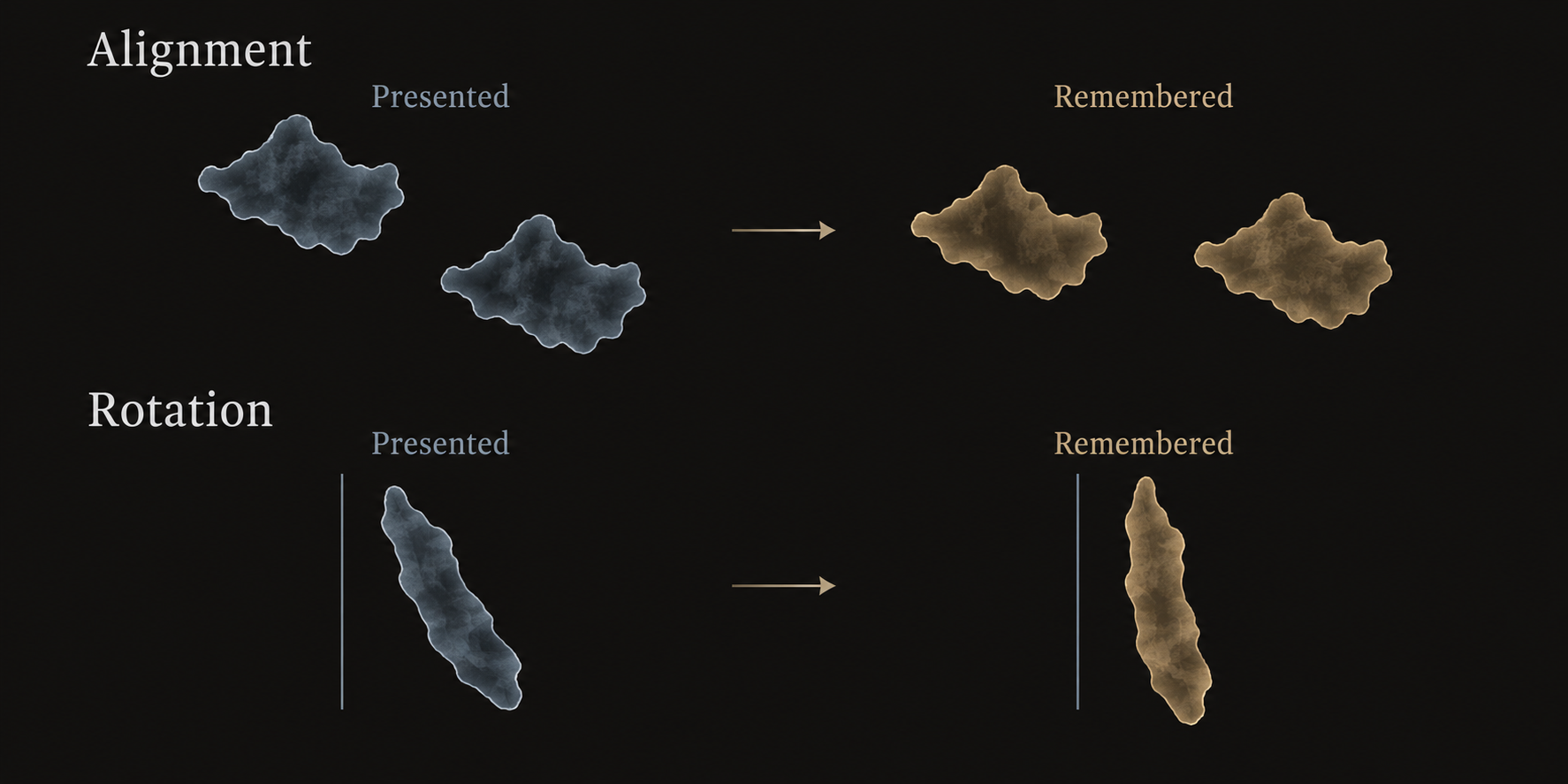
Both can occur together. Tversky suggests that remembered positions can be a compromise between the stimulus and a more regular structure. These heuristics may enter representation formation, retrieval, or inference. A final response alone does not locate the distortion entirely within one stage.
1.3 Moving a region can move the places within it↗
If cities are remembered relative to continents, a change in the subjective position of a continent can affect judgments between its cities. The paper uses the longitudinal offset of North and South America, and the relative positions of the Americas and Europe–Africa, to motivate alignment predictions: remembered continents may line up more than those shown on the map.
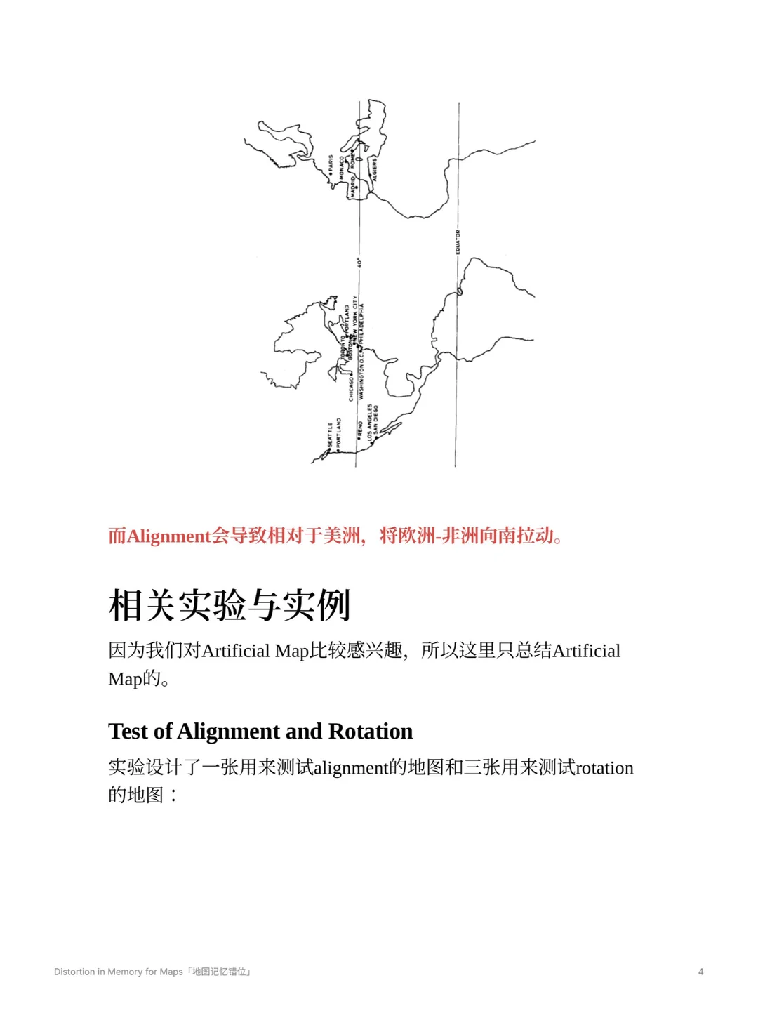
These are relationships within the paper’s projections and judgment tasks. A layout on one flat map should not be treated as a projection-independent account of geometry on Earth.
Chapter 2: Artificial maps and familiar streets↗
2.1 Artificial maps: learn, judge, then draw↗
To look beyond participants’ existing geographical knowledge, the study used one artificial map to test alignment and three to test rotation. Each contained four letter-labeled cities. The three rotation maps had triangular, elongated, and San Francisco Bay-like outlines.
The image below preserves the experimental stimuli from the paper’s Figure 5 as included in the original note. The hypothetical islands in the concept illustration do not replace these stimuli. Consult page 417 of the paper for the original figure and its orientation instructions.
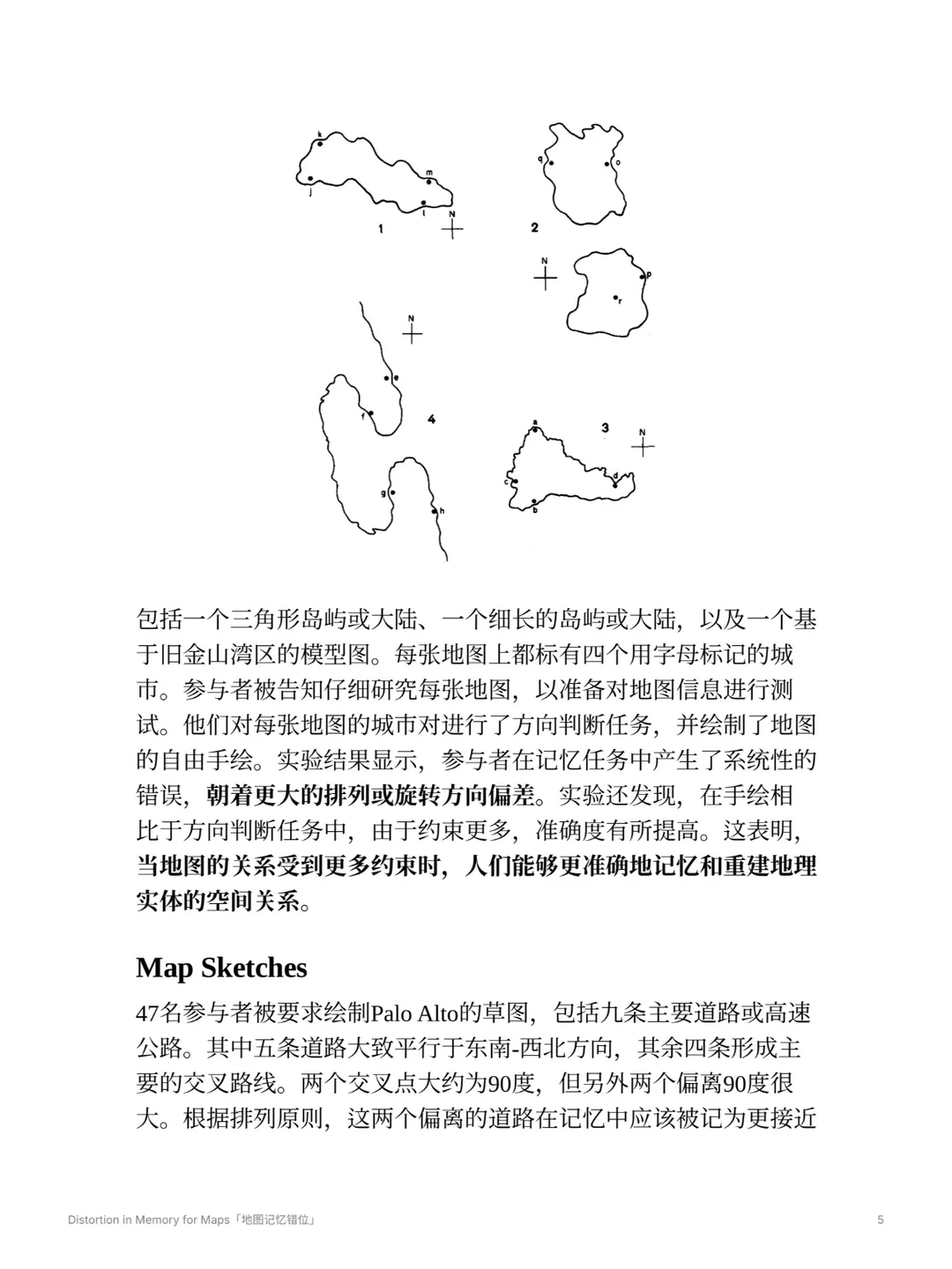
Twenty-four participants studied the maps individually for one minute each, then judged directions between city pairs and drew a free sketch. Critical pairs were chosen so that the true direction could be distinguished from the error predicted by alignment or rotation.
Both direction judgments and sketches showed systematic errors in the predicted directions. Sketch scores were slightly better than isolated direction judgments. The author suggests that drawing a whole map imposes several simultaneous constraints among cities and between cities and the outline. This comparison supports the value of relational constraints; it does not establish that adding any constraint will improve memory.
2.2 Palo Alto sketches: which observations entered the analysis?↗
Forty-seven participants were asked to sketch the Palo Alto area with nine major roads. Two sketches were excluded because they omitted too much. The street-angle findings concern the remaining 45 sketches.
| Observation reported in the paper | Count | Analysis set |
|---|---|---|
| Drew an approximately intersection as | 45 | The 45 sketches included in analysis |
| Drew an approximately intersection as | 35 | The same 45 sketches |
| Drew north towards the left of the page | 31 | The same 45 sketches |
These counts describe the study’s sample, not universal population rates. The first two concern street relations becoming more regular. The third needs to be considered alongside the alignment of streets with the page edges, the university’s placement, and whether the map could be “walked into” from the participant’s position.
North not pointing upwards is therefore insufficient, by itself, to establish an egocentric representation. Drawing on several internal features of the sketches, the author argues that participants may have reconstructed a familiar environment rather than copied a remembered conventional map.
Chapter 3: Questions to carry forward↗
Structured memory need not be a more accurate copy of coordinates. Reference frames help organize locations, but may also make relations too orderly. This preserves the original note’s central question: can the direction of an error help distinguish the structures used in representation and judgment?
The paper also includes local-direction and meaningless-form tasks. The examples discussed here do not cover every experiment in the paper. For a particular experimental paradigm, return to the methods and results rather than treating these phenomena as a complete, unified mechanism for cognitive maps.
Connections to georeferencing or Procrustes analysis require one further distinction. Applying a transformation to compare data is an analytical choice; whether human memory performs a corresponding transformation is a separate empirical question.